High-Fidelity Intelligence for Complex Decisions
As Camilla strengthens its position as a vital hub for Southwest Georgia’s logistics and manufacturing, the requirement for pinpoint accuracy in land data has become absolute. For the civil engineers, site managers, and municipal planners operating throughout Mitchell County, legacy surveying techniques are increasingly unable to match the velocity of modern development. Camilla Ag Drones represents a technological leap forward. We deliver more than just "bird's-eye views"—we provide comprehensive geospatial intelligence that serves as the foundational truth for your project’s most critical milestones.
Our methodology is designed to eliminate the common hurdles of regional surveying: expensive guesswork, personnel safety risks on active sites, and the logistical nightmare of traditional manned flight. Utilizing a fleet of Blue UAS certified platforms outfitted with top-tier sensors, we aggregate millions of precise data points across vast acreage in a single workday. Whether you are managing an aggregate facility in Mitchell County or surveying miles of utility infrastructure, we produce actionable datasets that integrate directly into your professional CAD and GIS ecosystems.
The Integrity of Blue UAS Certification
In an era of heightened digital scrutiny, the protection of your site's proprietary data is non-negotiable. All survey systems operated by Camilla Ag Drones are Blue UAS Certified, having undergone exhaustive cybersecurity and supply chain audits by the U.S. Department of Defense. For those managing critical infrastructure in the Coastal Plain—including energy grids and water systems—this certification provides the assurance that your sensitive geographical data is shielded from vulnerability, from the moment of takeoff to final delivery.
Volumetric Surveys: Absolute Inventory Control
For the industrial and mining operations of Mitchell County, knowing your exact stockpile volume is the difference between profit and loss. Relying on manual ground surveys is not only slow but places staff at risk near heavy machinery and unstable highwalls. Our drone-based solution removes the human risk while significantly narrowing the margin of error. Equipped with 61MP photogrammetry sensors, we capture ultra-high-definition imagery to build hyper-accurate 3D models of your entire inventory.
We process this information via PIX4Dmatic, the gold standard for large-scale volume analytics. This allows us to produce transparent, auditable reports on cut/fill and stockpile totals with centimeter-level precision. For accounting departments in Camilla, this turns the monthly reconciliation process from a headache into a streamlined, data-backed event. Within 24 hours of flight, your site is transformed into a measurable digital asset that can be analyzed and shared across your entire organization.
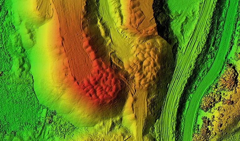
LiDAR Surveying: Piercing the Coastal Plain Canopy
The Georgia Coastal Plain is defined by its thick stands of pine and dense hardwood canopies, which often render traditional aerial photography useless for ground-level mapping. Development in Mitchell County requires a clear view of the terrain hidden beneath this vegetation. This is why our LiDAR (Light Detection and Ranging) services are the industry’s preferred choice. We utilize the Riegl miniVUX-2UAV, a sensor engineered for unparalleled vertical precision.
LiDAR functions by emitting millions of laser pulses per second that penetrate even the most stubborn forest cover. These pulses reach the earth’s surface and return, allowing us to generate a "bare earth" Digital Terrain Model (DTM). For Camilla developers navigating drainage challenges or engineers designing new commercial plots, this data is transformative. Our LiDAR captures offer better than 1-inch absolute vertical accuracy and a density of up to 800 points per square foot, exposing topographic details that are invisible to any other method.
Large-Scale Deployment & Multi-Aircraft Capability
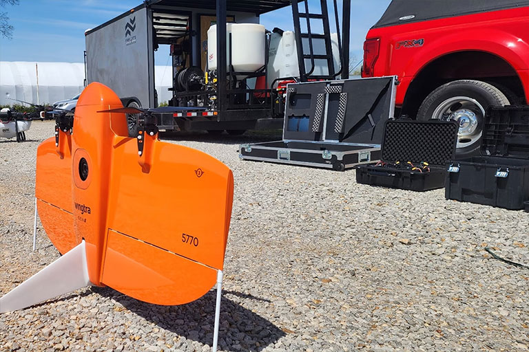
Scope and speed are the primary challenges for regional infrastructure. Most standard drones lack the battery life to cover significant territory, and traditional planes are too costly for routine monitoring. Camilla Ag Drones utilizes the WingtraOne Gen II, a fixed-wing VTOL (Vertical Take-Off and Landing) aircraft capable of mapping over 700 acres per flight—ten times the efficiency of a quadcopter. For Mitchell County’s largest industrial parks or massive timber tracts, we can deploy multiple crews and aircraft simultaneously.
This high-capacity approach allows for the collection of data over thousands of acres in a single day without a dip in resolution. Our integrated PPK (Post-Processed Kinematic) technology ensures every frame is geotagged with centimeter-level precision, drastically reducing the need for manual ground control. This speeds up your project timeline and minimizes our physical footprint on your site, providing a unified, massive dataset ready for immediate land-use planning.
3D Digital Twins & Site Visualization
Move beyond flat maps and experience your project through photorealistic 3D digital twins. Traditional blueprints often fail to convey the true spatial relationship of complex infrastructure. We create immersive, measurable 3D property models that allow Camilla stakeholders to explore, measure, and present their sites with absolute clarity.
By blending top-down and angled perspectives, we build textured 3D meshes and point clouds that provide a perfect "as-built" record. This is a vital tool for tracking construction progress, performing architectural studies, or marketing high-value regional assets. For developers in Mitchell County, a digital twin offers a verifiable chronological record of earthwork and structural placement, ensuring every phase of the project adheres strictly to design specifications.
Data Accuracy Specifications
Horizontal Precision
1.0 cm
PPK Enabled Precision
Vertical Precision
< 2.5 cm
LiDAR Terrain Data
Ground Sampling Distance (GSD)
0.7 cm/px
MAP61 Full Frame
Managed Workflow
Your dedicated Camilla Project Manager oversees the entire technical workflow, from sensor selection to data processing in Pix4Dmatic. We deliver actionable results in the precise formats your engineers require, including DXF, DWG, LAS, and GeoTIFF files.
Request Technical Scoping